A Boundary on Paper Is Not Always a Boundary on the Ground
Administrative boundaries and everyday routes do not always align. Learn to read a county map for jurisdiction, crossings, services and local connections.
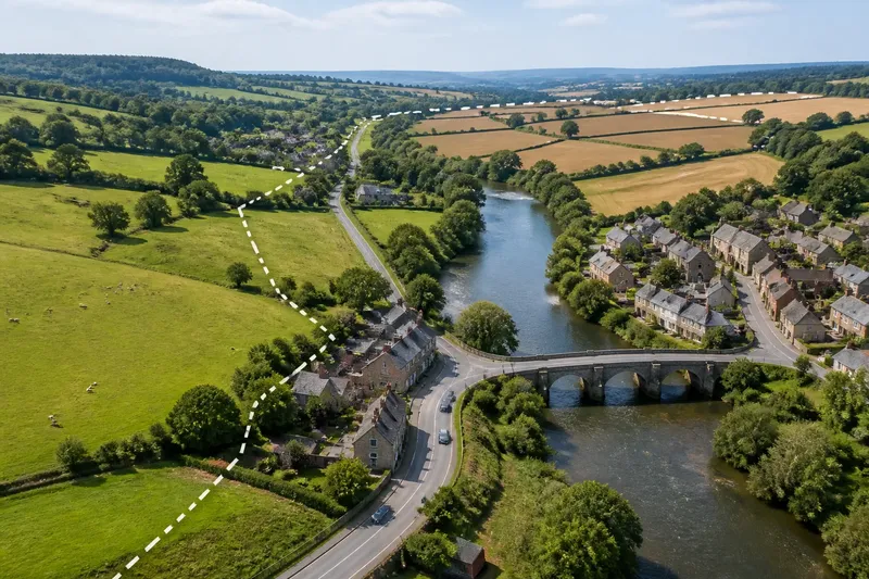
You can stand at a crossroads, follow the signed road to the nearest town, and still cross into another county before reaching its shops. Administrative boundaries and everyday routes often diverge: one line records who governs a place, while the road records how people get around. Reading a county map well means keeping those two kinds of geography apart.
That distinction matters when you are checking which council serves an address, tracing a school journey or trying to understand why a nearby facility belongs to another authority. A useful map-reading checklist can show what each line tells you—and what it cannot tell you.
What Does the Line Show?
A boundary line usually shows where an administrative area begins or ends. Depending on the map, that might be a county, district, parish, ward or another unit of local government. It does not, by itself, show a barrier on the ground or the route residents usually take.
Mapmakers use symbols to distinguish boundaries from roads, rivers and paths. A dashed or coloured line may mark an administrative edge; a solid line may represent a road or railway. Check the legend before interpreting either. If the map has several boundary levels, read its labels as well: a county edge and a ward edge may sit close together without being the same line.
A boundary can follow a river, cut across open land or pass through a built-up area. It may be invisible from the pavement. The line still has administrative meaning, but a person walking to a shop may never notice it.
Start by asking what boundary the map is intended to show.
Where Does Jurisdiction Change?
Jurisdiction changes at the mapped administrative line, not necessarily at a sign, bridge or change in street name. An address on one side may fall under one authority, while a neighbouring property falls under another. The boundary can also separate responsibilities at different levels: county-wide functions may coexist with services managed by a district, parish or other body.
To check an address, find a map that names the relevant administrative area and identify the property, rather than relying on its nearest town name. Towns, villages and neighbourhoods can extend across administrative edges, and an address’s postal town does not necessarily identify its local authority.
If you are trying to find who handles a particular service, treat the map as a starting point, then check the relevant council’s address lookup or contact information. A boundary map can locate a place within an area; it cannot, on its own, explain every service responsibility.
Why Do Routes Cross Boundaries?
Roads and paths connect destinations. Administrative lines divide areas for governance. Those purposes do not require the same layout, so a direct route may pass through more than one authority before reaching its destination.
Physical features influence routes too. A river may form part of a boundary, yet the nearest crossing could be far upstream or downstream. A railway may run across several districts, while a station serves people from both sides. A main road may link a village more closely to a neighbouring county town than to its own administrative centre.
Everyday connections can also follow bus routes, school catchments, shopping trips and access to health facilities. These are useful clues about how places relate in practice, but they do not redraw an administrative boundary. A bus stop near a boundary does not establish which council maintains the road, and a familiar local name does not settle who governs a particular address.
Trace the route separately from the line, and note where they meet or diverge.
How Should I Read a County Map?
Read a county map by checking its purpose, legend, boundary level and visible connections before drawing conclusions. This checklist helps keep jurisdiction and everyday movement distinct:
- Check the map title and date. Confirm that it shows the area and boundary type you need. If its purpose is unclear, choose a more specific administrative map.
- Read the legend. Match the line style and colour to its meaning. If several lines look alike, do not assume they all mark the same kind of boundary.
- Identify the place precisely. Use a named road, property or map reference rather than a broad place name. Then check which side of the relevant line it lies on.
- Trace the route to the destination. Follow roads, footpaths, bridges and crossings independently of the boundary. This shows where a journey changes direction or crosses an administrative edge.
- Look for physical obstacles and access points. Note rivers, railways, limited crossings and connecting roads. A nearby destination may be less accessible than one farther away.
- Check labels and neighbouring areas. Compare the county, district or other unit named on the map with adjacent areas. If the map only shows one level, seek a map that shows the level you need.
- Separate the question from the answer. For responsibility, check the authority serving the address. For travel or local connections, follow the mapped routes and relevant transport or access information.
Say you are looking at a village near a county edge because its nearest library appears to be just across the line. You mark the village address, trace the available road and river crossings, and check which authority the address belongs to. The map may show that the library is an easy journey but lies outside the village’s county; the authority lookup answers the jurisdiction question, while the route answers the access question.
Which Map Should I Use?
The right map depends on what you are trying to establish. An administrative boundary map is best for locating an address within a county or other governing area. A road or topographic map is better for seeing routes, terrain and crossings. A public transport map can show service connections, but it may omit smaller paths and administrative edges.
Some maps combine these layers. That can be convenient, but it also makes the legend especially important: a bold road line can draw the eye more than a faint boundary, and a boundary line can appear to follow a road even when it crosses it elsewhere. Zooming in may clarify the relationship, though a clearer view does not replace checking what the map represents.
For a specific service or property, use the authority’s own address tool where available. For movement between places, compare route information with visible barriers and crossings. No single map is likely to answer both questions equally well.
What Do Place Names Tell Me?
A place name tells you how people identify a location, not necessarily which authority governs it. A village may share a name with a wider parish, a postal area or a settlement that straddles a boundary. Likewise, a town commonly described as belonging to one county may contain addresses in a neighbouring administrative area.
Local names are still valuable. They help you locate schools, halls, shops and meeting places that residents recognise. Use them to find the area, then use a precise address and boundary map to establish jurisdiction. For a local connection, look at how the road, bus or walking route links the named places.
What Questions Should I Ask?
Does a nearby town decide which council serves an address?
No. A nearby town or postal name may help you locate an address, but it does not settle its administrative area. Check the exact address against a suitable boundary map or the relevant authority’s address lookup.
Can a road follow a county boundary?
It can run beside a boundary, cross it or form part of the mapped edge, depending on the place and map. Compare the road symbol with the boundary symbol in the legend before deciding where the line lies.
Does crossing into another county mean a different service provider?
It may mean a different authority is responsible, but the answer depends on the service and the address. Check the authority information for that specific service rather than inferring responsibility from the route alone.
Why does the nearest facility sometimes belong to another area?
Facilities and boundaries do not have to share the same geography. A road, bridge or public transport link may make a neighbouring area more accessible, even though the facility sits outside the resident’s administrative area.
What Should I Check Next?
When a county map seems to disagree with local experience, ask which question you are answering. For governance, locate the address and identify the right administrative unit. For everyday connection, trace the route and note the crossings, obstacles and services along it. Keeping those questions separate is the simplest way to read administrative boundaries and everyday routes without treating one as a substitute for the other.
A boundary may be easy to miss from the road, but it can still matter for local responsibilities. A route may cross it without changing how residents describe their neighbourhood. Check the map’s legend, then let each source answer the question it was made to answer.